The project Trajectories of Social-Ecological Systems in Latin American Watersheds: Facing Complexity and Vulnerability in the context of Climate Change (TRASSE) will identify which are the social (governance, economic, cultural) and biophysical dimensions whose interactions determine the trajectories in time of rural-urban watersheds SES in terms of measurable outcomes such as the flow of ecosystem services –in particular water regulation services-, land management strategies and human well-being. This will allow operationalizing the Social-Ecological System framework at the sub-watershed and watershed scales in order to predict what possible future trajectories might or might not be viable in terms of coping with climate change vulnerability and ensuring human well-being.
Working package 1
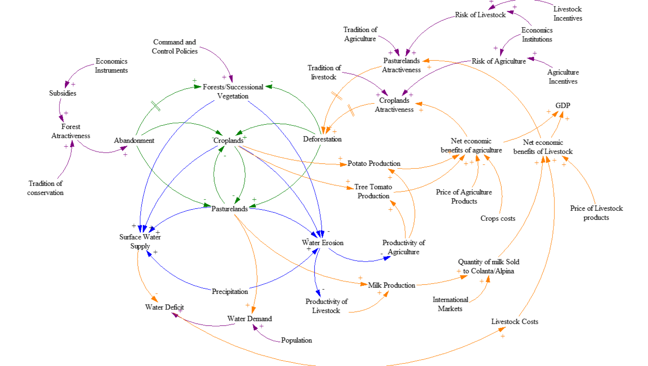
Operationalization of SESs and links with vulnerability framework This first working package has the objective of operationalizing the SES in terms of its boundaries and main variables. Whereas the existing works developed by Hinkel et al. (2015), Schlüter et al. (2014) and Bennett and Gosnell (2015) have operationalized the SES at a generic level using sub-systems that represent the different landscape social-ecological entities (stream, forest agriculture, farmers etc.), we will define SES in an interlinked manner as part of larger SES or meta-SES. This spatialization will be done by combining homogeneous governance and biophysical criteria. In a second step, we will do a literature review to identify the 2nd and 3rd level variables. Finally, we will validate this first operationalization with two workshops.
In particular, WP1 will consist on:
Spatial delineation of SESs: Using existing statistics we will build a spatial explicit mapping of agricultural (type of production system and crops), poverty, biophysical (slope, land cover) and land tenure (private vs community property) indicators in order to identify homogeneous patterns. These SESs will be identified as SES 1, SES 2 and so forth.
Identification of 2nd and 3rd level variables and interactions: Second, we will perform a literature review in order to identify 2nd and 3rd level variables and interactions that are pertinent for describing the identified SESs (See Annex 1).
Identification of the links between SES key variables and climate change vulnerability: Following Bennett et al. (2016) vulnerability framework we will identify which SES key variables correspond to exposure (e.g. defined by climatic history and climate change scenarios), sensitivity and adaptation (e.g. access to human, social, physical, financial and natural assets, capacity to organize, leadership, learning and knowledge, imaginative resources and capacity to self-organize).
Validation workshops with stakeholders – Identification of local indicators of climate change: In order to validate the conceptual operationalization of the rural-watershed in SESs we will conduct at least participative workshops. The workshops will gather local actors –farmers, technical intermediaries, local community leaders, local authorities- and regional and national actors in different occasions, in order to frame the discussions to the geographical scale in which actors feel more confident. We expect local actors to bring local indicators of climate change while regional and national actors will have a better understanding of the interactions, outcomes and external settings (e.g. drivers of change).
LEADERS
Maria Perevotchikova COLMEX-CEDUA
Driss Ezzine-de-Blas CIRAD-FORETS
Working package 2
Tracing the social-ecological history of the landscape: A historical analysis of productive systems, ecological disturbances and governance dynamics The study of social-ecological rural-urban watersheds needs to be, first of all, approached from a historical perspective in order to understand the economic process of regional integration, what policies and governance institutions have shaped the territory and the main ecological disturbances that shaped their development. This working package will identify convergent and divergent changes in what have been the main productive systems, how forests have been integrated or disaggregated from productive landscapes, the investment in hydraulic facilities, the expansion of urban centers and the type and mix of conservation and development policies that have come into action.
In particular, WP2 will consist on:
Description of the process of regional integration (evolution of land uses and productive systems) and main ecological disturbances: First, we will perform a bibliographic review of the main phases in the expansion of the agricultural frontier, and the evolution of productive systems and agricultural management practices. Main ecological disturbances will be identified and described, such as e.g. arrival of pests, large fires, droughts, building of dams.
The review will be enriched using a socio-economic approach based on semi-structured interviews with key stakeholders from the productive and forest conservation sectors at regional and national levels.
Chronology and mapping of conservation and development policies: A bibliographic review will be performed to understand what policies were put in place in the studied landscapes. These policies include green markets, integrated conservation and development projects, protected areas, agri-environmental measures etc.
This review will be completed through interviews with local and national experts that have been involved in the implementation and study of forest conservation and development policies in the area.
Analysis of governance dynamics and mapping of institutions (cooperatives, farmers’ associations, environmental associations, consumer groups): Tasks 1 and 2 will be completed with a sociological and institutional economics analysis specifically targeting the evolution of governance institutions in terms of cooperatives, association of farmers, researchers, technical intermediaries, community based management institutions.
The qualitative information will mapped so to locate of the different types of institutions,. in a flow diagram showing the multi-layered governance structure of the landscape in order to explore the evolution of networks between organisations (polycentric vs monocentric governance) as a measure of social capital at the SES level.
LEADERS
Jean-François Le Coq CIRAD-ARTDEV
Sophie Ávila-Foucat UNAM-IIEC
Working package 3
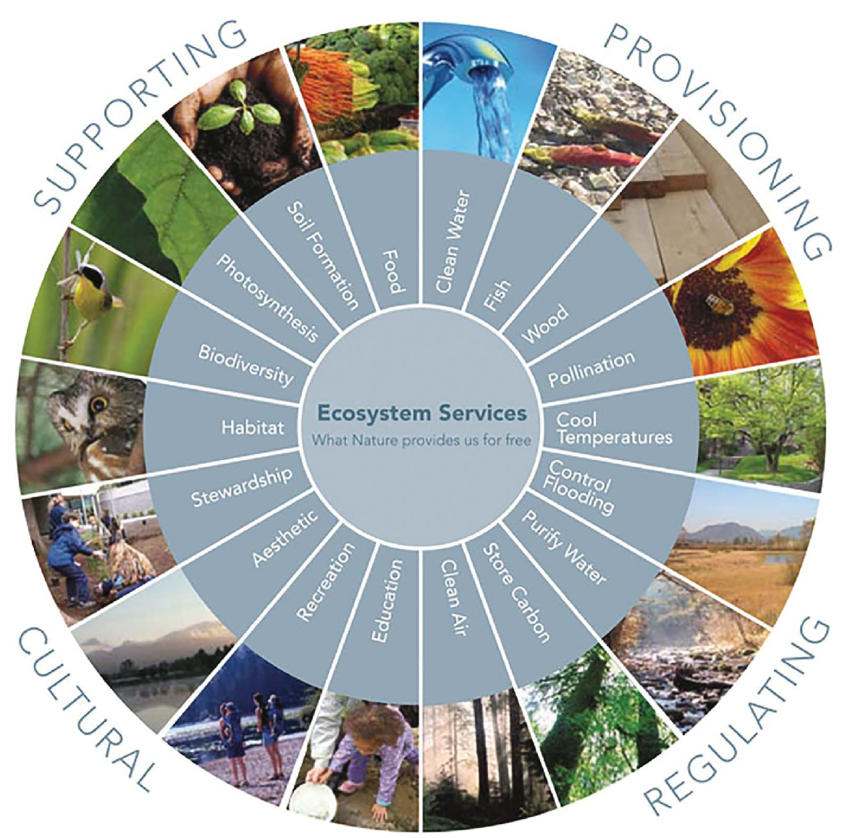
Ecosystem services transitions: exploring the evolution of types of services produced by the SESs This working package will summarize complex spatial and temporal dynamics of land-use changes integrated with socio-institutional data (public policies and networks actors influencing the land cover dynamics – WP1 & WP2). First, we will use the Invest model (http://www.naturalcapitalproject.org/invest/) to map several types of ecosystem services indicators (climate regulation through carbon storage, water cycle regulation through infiltrability, ecosystem regulation through biodiversity populations). Second, we will use statistical methods to forecast the distribution of service indicators such as regression tree (CART algorithm) or multiple linear regressions (Vallet et al., 2016). The multi-temporal land cover mapping will be obtained from geometrically and radiometrically corrected satellite images to characterize the composition and structure dynamics of land use changes in order to capture key forest-agriculture outcomes such as the degree of agricultural intensification.
In particular, WP3 will consist on:
Mapping of ecosystem services indicators: The mapping of climate regulation through carbon storage, water cycle regulation through infiltrability, ecosystem regulation through biodiversity populations will be done using InVest model.
Elaboration of a multi-temporal land cover analysis: Such a multi-temporal a land cover analysis will produce two main outcomes: a land use change map and overlapped principal component analysis of how land use has changed inside each of the governance units and of the SESs.
LEADERS
Bruno Locatelli CIRAD–FORETS
Johan Ozswald CIRAD-FORETS
Working package 4
Spatiotemporal trajectories, vulnerability implications and social-ecological theory of change for the sustainability of SES This WP will perform integrative tasks on a retrospective and prospective manner. First, empirical data obtained in WP2 and WP3 will be integrated to generate a first lineal semi-quantitative identification of past social-ecological trajectories. Second, in order to integrate the social and ecological results from WP2 and WP3, WP4 will perform an integrative modelling using the Ocelet language and simulation tool. Ocelet models changes in geographical landscapes through the use of interaction graphs to represent the different sub-systems in each SES. Ocelet allows spatially locating these different sub-systems and specifying the interactions among them to make the system change through time. Modelling the past behaviour will explicit the trajectories of the SES and how they relate to the resilience of the system and to their vulnerability under climate change scenarios. Finally, we will perform prospective analysis to understand how business as usual vs best case scenarios might affect the sustainability of the whole watershed.
In particular, WP4 will consist on:
Definition of entities and model specifications.
Integration of empirical evidence and simulation of past trajectories: Empirical data obtained in WP2 and WP3 will be int generate a first lineal semi-quantitative identification of past social-ecological trajectories and elaboration of prospective scenarios.
Simulations will be guided by the main processes and interactions identified and empirically described in the previous WPs. An example of processes will be i) the geographical distribution of plots as a means to face climatic risks, ii) the effect of fallowing practice in a spatially constrained cotton dominated landscape and iii) the consequences of reduced access to credit for farmers to buy fertilizers.
Comparison of results and description of a social-ecological theory of change for sustainable SES: Retrospective trajectories based on empirical evidence and prospective modelling will allow identifying pathways of change. Pathways of change will be systematized to identify which SES key variables, interactions and outcomes have been the more decisive in generating the observed changes both in terms of sustainability and degradation. This generic pathway of change will be enounced in terms of causal mechanism or theory of change.
LEADERS
Valéry Gond CIRAD–FORETS
Lucia Almeida UNAM-Facultad de Ciencias
Working package 5
Coordination, dissemination and monitoring of transdisciplinary project thinking. This working package will assure the scientific and administrative reporting. It will also deal with project management needs. Besides, although focusing on coordination, communication and dissemination, this working package will monitor the evolution of interdisciplinarity research and transdisciplinary thinking among the scientists involved in the project.
TRASSE brings together about 40 international scientists from different academic institutions who are experts in their different fields of research in order to provide answers to the complexity of the problem studied. Sustainability research is problem-oriented (e.g. climate change) and addresses complex issues that must be explored from multiple perspectives sourced from the natural and social sciences (Locatelli et al., 2020). Interdisciplinarity research is therefore at the heart of the TRASSE project.
Interdisciplinarity research is a dynamic process defining as “a mode of research by teams or individuals that integrates information, data, techniques, tools, perspectives, concepts, and/or theories from two or more disciplines or bodies of specialized knowledge to advance fundamental understanding or to solve problems whose solutions are beyond the scope of a single disciplines or area of research practice.” (National Academies, 2004, p.2). Interdisciplinarity research can occur and be measured at different levels, such as intra-, inter-personal interdisciplinarity (Haeussler et Sauermann, 2020); and collective (Locatelli et al., 2020).
Thus, the objectives of this study is to assess the process of building interdisciplinarity research along the project by analyzing the interdisciplinary interactions between project scientists, theirs evolutions in time and what are the outcomes of pooling everyone's perspectives into the study of a common problem through the conduct of a longitudinal social network analysis (SNA).
LEADERS
Driss Ezzine-de-Blas CIRAD-FORETS
Bruno Locatelli CIRAD–FORETS
Laura Mazaud OREGON STATE UNIVERSITY